
This Digital Humanity project, that is titled “Digital Maps Are Giving Scholars the Historical Lay of the Land” and composed by Patricia Cohen, heavily deals with the field of spatial humanity. It also illustrates how digital maps and GIS, geographical information system, can be helpful for scholars to yield a more comprehensive understanding toward the graphical layout of important historical events.
To better understand the uses and significance of GIS, I recommend one to probe deeper into this National Geography education presentation of GIS. It provides not just a comprehensive description of what GIS is and how it is employed but it also introduces readers with interactive media examples. This greatly assisted me to interpret the essence of this DH project.
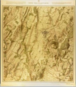
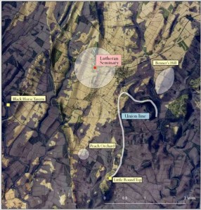
Just as most DH project, this project differs than any other ordinary websites that it presents the readers with sophisticated digital assets through technical structure. Particularly, the article obtains assets or sources of an 1875 topographical map of Gettysburg and documented description of troops position, scenery, renderings of historical roads, fences, buildings and vegetation during the Battle of Gettysburg in July 1861. These would later become essential sources for demonstrating the power of GIS to map spatial information.
Afterwards, these sources are processed as Anne Kelly Knowles, a geographer from Middleberry College, digitalize them into a GIS program to ultimately allow viewers visualize the geographical position of the battlefield more thoroughly. Finally, Ms Knowles and her colleagues, by employing GIS, were able to recreate a digital presentation or structure of the original battle that provides a ‘viewshed’ analysis illustrating the view of Gen. Robert E. Lee during the second day of the Battle of Gettysburg.
 Furthermore, the DH project later also reveals that Benjamin Ray, director of the Salem Witch Trials Documentary Archive, also have presentable sources, case studies regarding the spread of witchcraft trials in 1692. By digitalizing these sources into certain GIS programs, Benjamin Ray was able to visualize and recognize how the incident of witchcraft trials was able to spread so rampantly in 1692 through 25 communities, whereas previous occurrences were more regional. Moreover, after applying more sources of church affiliation of these instances, he was also able to conclude that there was a correlation between the churches and accusers, which created a fissure in the village.
Conclusively, the DH project demonstrated that GIS, such as Google Map, GPS system and Map Quest, can be powerful system to illustrate the significance of spatial humanity and edify us with a unique perspective toward important historical event.
I thought that your post did a great job explaining what GIS is, and it made me realize that I didn’t exactly know what GIS was before reading your post. This included the links to other sites explaining exactly what GIS is. I liked the organization of your blog post as it made sense and was the correct length. I thought that the maybe the first picture was unnecessary and you could have used that space for a picture of the project. GIS is an important digital humanities tool and in this case was used for recreating historical events. This offers us a new take on the event or new information/analysis can come to light.