
Progress:
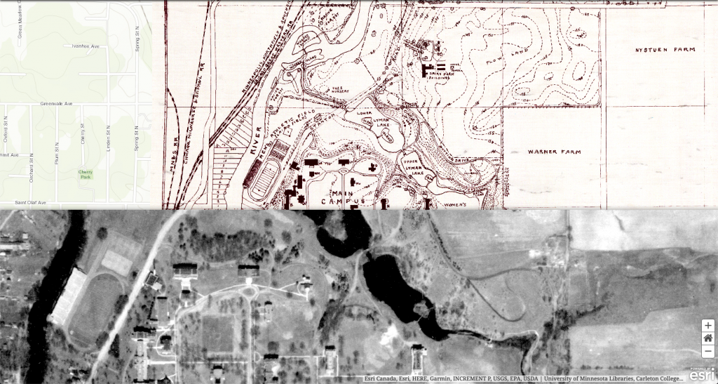
We looked at GIS map layers that contain historical aerial images of Carleton College. We also looked at the story maps that Austin recommended us to look at: “Change from the Above”, “Age of Megacities”, and “London’s Lost River.” We were intrigued and started by just building a serial of aerial image slideshows like “Change from the Above.” We plan to incorporate more elements including elements later, like ArcGis shape layers of campus buildings through time. The shape layers would allow us to provide a detailed inspection of Carleton’s expansion throughout time.
Problems (and proposed solutions)
Right now, we are struggling to align map layers in the cascade story maps. It is a lot easier to match the location of images since the web app allows users to place the images and specific locations with references to the previous slides. While for maps, it is a much bigger hassle. When we tried to adjust the map’s placement by dragging the map in the elements tab, the changes were not saved in the slides. The only adjustments of the maps’ placement that were saved were done through “manage” – “edit,” in which references to previous slides were not provided. In short, users need to match the location of maps blindly since references are not provided. We tried to address this by using one single map that contains every layer, creating duplicates of the map in the story map, and then enabling specific layers for each duplicate. This attempt still failed as the transitions did not work. We plan to try setting this up with manual adjustment on maps later.
We also do not have the permission to create shape layers in ArcGis. In case we continue to not have the permission to do so, we have considered using rastered layers instead of vector layers.
Regarding our original idea, we considered using 3d models of the college to make a “time-lapse” animation: showing how buildings were built and torn down through time. However, we believe that an animated video does not interact with the audiences enough: we believe that a story map can allow the audiences to interact with the time and spatial changes better than just a video. The process of working with 3d modeling also would be very time-consuming so we do not know if we can finish animation before the deadline for the project.
Tools and techniques
We are using esri story maps, ArcGis. In case we make animation, we will potentially use city engine and sketchup for 3d model animation. Deliverables
Updated timeline
March 3rd: An esri story map with satellite images, shape layers that displays Carleton’s campus expansion over time.
March 9th: Additional plausible element being added to the story maps. Potentially an animation video.
Alan: https://alanranzheng.com/final-project-update-week-8/
Amelia: http://ameliaexploring.com/hackingthehumanities/final-project/

Hi Team,
Regarding the alignment issue, there are a few possibilities. You should be able to control layers in a map between different views, as you suggest. If you want to align different maps, the best bet would probably be to set their initial extents the same. You can edit the extent of the map on the settings page and could, e.g. search for Carleton College and set the resulting extent on both maps.
On creating vector layers, this should be possible by making the feature layer editable from the settings page, and you should have permissions to do that. We can look again in class to make sure this happens.