From the Commonplace Book:
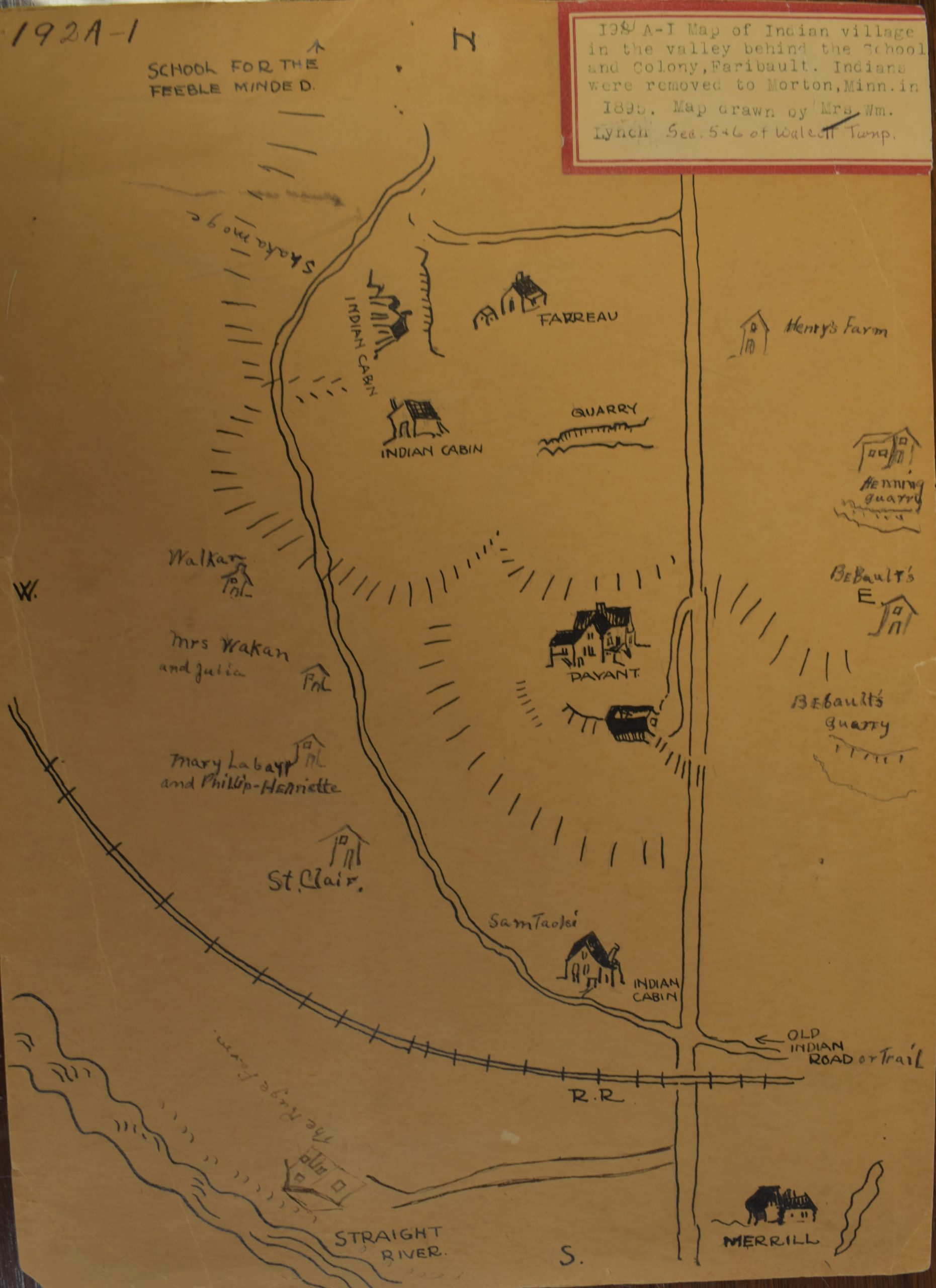
This project was initiated by the Rice County Historical Society with the goal of increasing awareness of the historical Dakota presence in Rice County. As it evolved, we narrowed our scope to focus primarily on one hand-drawn map in the RCHS collections, “Map of Indian village in the valley behind the School and Colony, Faribault. Indians were removed to Morton, Minn. in 1895. Map drawn by Mrs. Wm. Lynch Sec. 5+6 of Walcott Twnp.” The map shows the names of various Dakota families living in Faribault following the US-Dakota War of 1862, according to Lynch’s recollection.
Following consultation with Marcy Averill, Carleton’s Indigenous Communities Liaison, we decided that before anything public-facing could be made, further input from the Dakota community would be needed. Instead of working towards some sort of public interpretation of this history, we would solely collect information for a non-public database, which could be used later if it was found to be useful. We wanted to avoid narrativizing or interpreting this history, as the stories of the people involved are not really our stories to tell — and throughout our research process we’ve realized there’s historically been too many people ready to tell these stories without letting those with ownership over their history speak for themselves. The work we have done in this course has emphasized the ways in which traditional maps can erase or oversimplify the complex histories of the landscape, and we wanted to avoid reproducing the very issues we had spent the term critiquing.
Building off of previous research the RCHS had done into the people named on the map, we worked to compile all the available sources we could find mentioning those individuals and their families. We also worked on imagining what an interactive version of this map might look like. One of our primary sources of information were Warranty Deeds that documented the sale of land from these residents to Stephen Jewett, the treasurer of the Bishop Seabury Mission which was located to the East of the area shown in the map. Since these documents were also in the possession of the RCHS, linking them to the map could be a way to make them more easily available. If in the future more documents are found in the RCHS collections which relate to the map, they could be added to the Omeka library and links could be added to the map. We hope that the work we have done could potentially serve as a jumping off point for those who want to do further research on this subject, as well as potentially help the RCHS move towards making some of their files more easily accessible to future researchers.
Links to Omeka Library & Neatline Map of Indian Village in Faribault (permissions limited until approved by partners)