We’ve spent the first few weeks of term getting a crash course in the technical infrastructure of web-based digital projects, and we have looked at how Content Management Systems like the WordPress platform this site runs on process and present data.
For most Digital Humanities projects, however, the data are going to be much more structured than blog post content. Figuring out how to model real world data in a way that let’s you answer your question or meet the goals of your project is a key part of any endeavor.
This week we are going to get a first taste by diving into the archives and beginning to gather data for our class project making a digital/physical 3D model of Carleton’s buildings.
Over the next few weeks, this process will involve a number of steps
- Choosing a building as yours
- Researching the building in the archives to find images and historical information about it
- Building a collective website on the buildings’ history
- Making a digital map of campus
- Laser cutting a physical version of the digital map
- Refining a 3D model of your building
- 3D printing a physical version of the digital model
- Putting it all together by placing the building models on the map and linking them to the online information
Luckily, we are not starting from scratch in this process — previous students working with our GIS Specialist Wei-Hsin Fu and our Academic Technologist for Digital Scholarship Andrew Wilson have already made a 3D digital map of Carleton’s buildings.
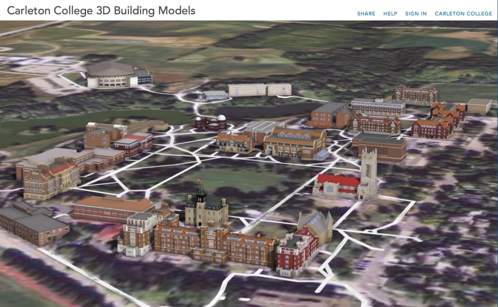
We are going to get familiar with how this project was made, and enhance it by printing a physical version and linking it to an online resource.
For this first pass, you are each going to choose a building as your own to research and eventually 3D print a SketchUp model of.
In Class: Metadata and Omeka
In class we will discuss the college archives and collections and talk about the importance of metadata. Our excellent librarians have provided us with detailed guidance on how to translate the metadata found in the archives into the standard Dublin Core metadata schema employed by Omeka.
Once we collect this data, we will import it and build a collection in an Omeka site, but we’ll start (as many good DH projects do) gathering data on the simple spreadsheet that you should have access to in Google Drive.
Have a look at the Carleton Campus Buildings list and think about which building you might want to model
Once you’ve seen a few pictures and have an idea of what you want, put your name in the Researcher column to claim your building
1) Fill in the rest of the basic information from this list of historic buildings maintained by facilities
Once you have chosen a building:
- Search all the different archival databases to find as many images of your physical building as you can find
- The librarians have set up a course guide for us that should be your starting point for entry into the archival holdings.
- Create a new folder for your building in the BuildingData folder of our shared Google folder.
- Download each image file you find and move it into this folder
- Then document all the metadata, following the instructions in this Metadata Guidelines for Dublin Core document
- Add records for each image to the
Data Entry Spreadsheet
Assignment: Metadata and Zotero
Brandon Walsh has created a helpful online book with resources and lessons on text analysis (which we’ll discuss in more detail later in this course). He includes a good discussion on metadata and the importance of data cleaning — which is a fundamental step in any project, whether storing data in a flat table or relational database.
Read through the post on data cleaning, and how to setup up Zotero, if you haven’t already. Think about how the metadata are stored and how this database works, as opposed to the WordPress instance. We’ll pick this up in future classes.